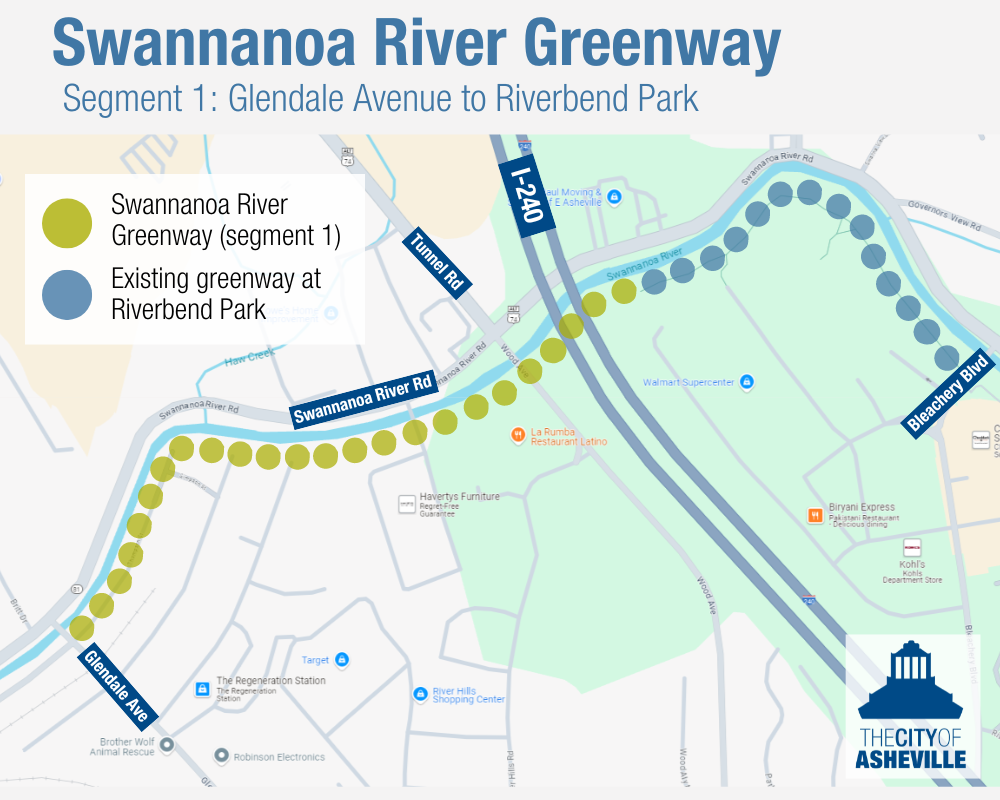
Overview
The Swannanoa River Greenway starts at the intersection of Lyman Street and Amboy Road and ends at the city limits located at Azalea Road and Tunnel Road. At seven and a half miles in length, the project will be broken into phases rather than completed simultaneously.
This video provides a more detailed explanation of Swannanoa River Greenway project. (Construction timelines have changed since the creation of the video.)
Happening Now
Construction on Segment 1 of the Swannanoa River Greenway will begin in 2024 and is estimated to take 12 months to be completed. This segment begins at the intersection of Glendale Ave and Thompson St. At a little over one mile in length, this phase will end at the WalMart on Bleachery Avenue. Future phases of the greenway will be largely implemented in conjunction with NCDOT’s Swannanoa River Road Improvements project.
Next Milestone: Construction kickoff
Background
The Swannanoa River Greenway project is a 2016 voter-approved Transportation Bond project and was identified as the City’s number one priority greenway in the GAP Plan. The project is also part of the future 100-mile Fonta Flora State Trail, connecting Morganton to Asheville.
The Swannanoa River Greenway starts at the intersection of Lyman Street and Amboy Road and ends at the city limits located at Azalea Road and Tunnel Road. At seven and a half miles in length, the project will be broken into phases rather than completed simultaneously.
Below is an image of the first segment of the Swannanoa River Greenway, to be built in 2024/2025.
In 2018, The City of Asheville conducted two studies on different segments of the Swannanoa River Greenway:
- Swannanoa River Greenway Feasibility Study (Phase 1) was a feasibility study and greenway corridor design on the eastern end of the greenway starting at the intersection of Thompson St and Glendale Ave and ending at the City of Asheville’s park complex with the Nature Center, Recreation Park and JB Lewis Soccer Fields. This study included the design for the first segment of the greenway from Thompson St to Bleachery Blvd.
- Swannanoa River Greenway Corridor Study (Phase 2) was a planning study funded through the NCDOTs Bike and Pedestrian Mini-Grant Program for the section of the greenway that starts at Biltmore Avenue and ends at the intersection of Thompson Street at Glendale Ave. This did not include engineering and design in the scope of work.
Supporting Documents
The City of Asheville Close the GAP Plan
The City of Asheville 2013 Greenway Master Plan
The Buncombe County Greenway Master Plan
The Hellbender Regional Trail Plan
Timeline
2018
After the 2016 voter-approved bond, the City of Asheville conducted two studies on segments of the Swannanoa River Greenway: Swannanoa River Greenway Feasibility Study (Phase 1) and Swannanoa River Greenway Corridor Study (Phase 2).
2020
Design work
2021
September: Public Meeting for feedback on the greenway design
2022
City Council adopted the GAP Plan, identifying the Swannanoa River Greenway as the City’s number one priority greenway.
2023
Design documents completed
Bid posted for construction
2024
Permitting and review
Summer: Anticipated construction start for first segment
2025/2026
Anticipated construction completion for first segment
Contact Information
Lucy Crown, Greenway Planner, Transportation Department
Dustin Clemens, Capital Projects Division Manager, Capital Management Department