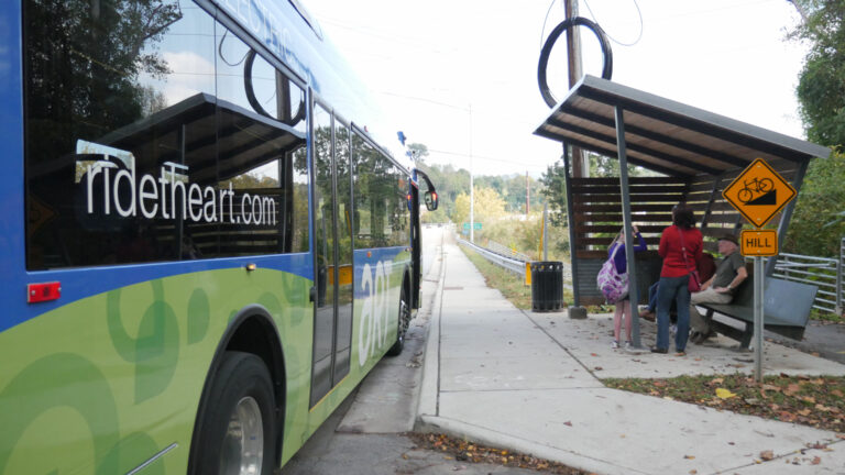
Background
On May 18, 2026, the City of Asheville released a Draft Network Report outlining potential future changes to the Asheville Rides Transit (ART) bus network. The report was developed by City Staff and consultant Jarret Walker and Associates with input from previous rounds of public engagement.
View the Draft Network Report
Visit the Project Page
All transit agencies have to balance competing goals – high ridership or coverage of more areas. With limited resources, cities have to make smart, informed trade-offs. The City’s population and land use is constantly changing, and it’s important that the services residents use evolve and develop to align community needs with resources.
The Asheville City Council requested a draft network that moved slightly in the direction of more ridership, while ensuring public housing and more transit-dependent neighborhoods would retain coverage.
The draft network would preserve the existing split between goals of ridership and coverage, but make adjustments to increase frequency on some routes, better coordinate route connections and improve on time performance.
The draft network would remove service from some areas in order to reallocate resources to areas where frequency is increased to 15 minutes.
Draft Network Details
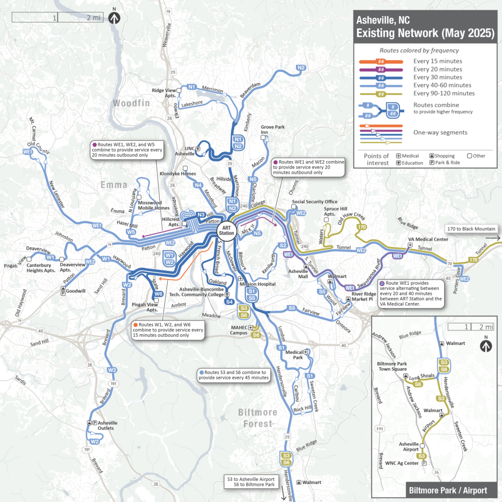
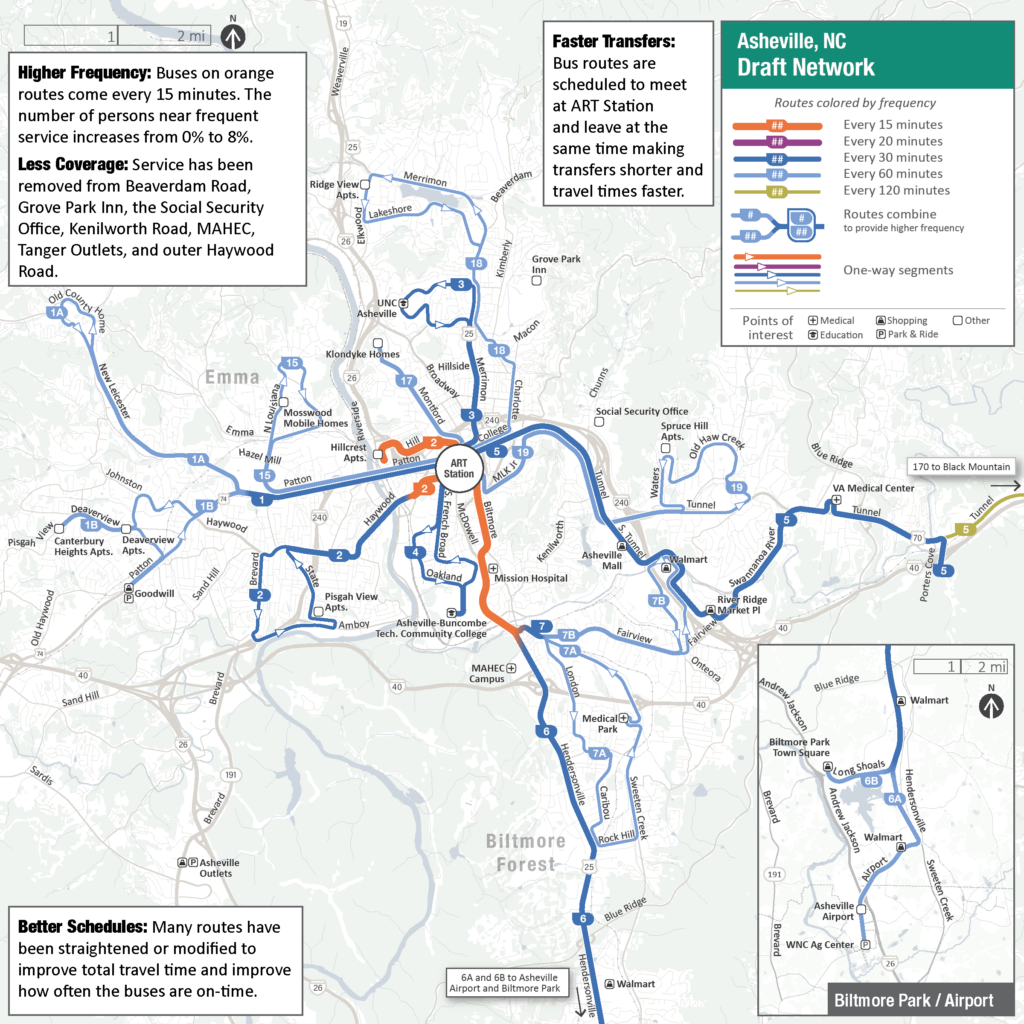
Comparing the two maps below illustrates the system-wide changes.
Existing Network
In the existing network, most routes run every 30-60 minutes, and a few routes run less frequently.
Orange lines mean a bus coming every 15 minutes most of the day.
Purple lines mean a bus every 20 minutes.
Dark Blue lines mean a bus every 30 minutes.
Light Blue lines mean a bus every 60 minutes.
Tan lines mean a bus every 90-120 minutes.
Draft Network
In the draft network, there are fewer total routes, but in some places, service runs more frequently than today.
Orange lines mean a bus coming every 15 minutes.
Dark Blue lines mean a bus every 30 minutes.
Light Blue lines mean a bus every 60 minutes.
Tan lines mean a bus that only runs during peak hours.
The draft network would provide more access to frequent service:
- 8% of all residents would be near the new 15-minute stops. A total of 37% would be near stops with service every 30-minutes or less, a 10% gain over the existing network.
- 11% of low-income residents and 10% of residents of color would gain access to buses that come every 15-minutes. Note, these percentage increases are higher than the 8% increase averaged across all residents.
The draft network would provide increased access to jobs:
- 31% of jobs would be near 15-minute frequency service and 54% would be near 30-minute service or better.
- The average resident could reach 9,000 jobs within 45 minutes by walking and taking transit, an increase of 10% over the existing network
- Access to jobs would increase by 15% for low-income residents, 11% for households without cars and 16% for residents of color.
The draft network adds timed connections at ART Transit center. Many buses would arrive at the central station at the same time, meaning riders would only have to wait 5-10 minutes to change buses, rather than waiting up to 59 minutes for a transfer.
In order to make these improvements, the network would reduce the percentage of residents near transit service, from 61% to 58%. Service would be ended in some areas in order to reallocate resources and improve frequency elsewhere in the system.
Changes by Geographic Area
North (view map)
Removal of Coverage
In the North, the Draft Network would remove service from these places:
- Grove Park Inn – Northbound service would no longer turn from Charlotte Street onto Macon Avenue and continue to the Grove Park Inn. Instead, northbound buses on Charlotte Street would turn left onto Edwin Place, then join Merrimon Avenue and provide service to the Lakeshore area.
- Beaverdam Road – Related to these changes, Northbound service would no longer turn right from Merrimon Avenue onto Beaverdam Road, but would continue on Merrimon Avenue to serve the Lakeshore area. Beaverdam Road stops have low ridership compared to others in the system.
Higher Frequency
In the North, the Draft Network would have frequent, 15-minute service from Hillcrest Apartments to Downtown
Other changes
UNC-A would still have 30-minute service like today, but instead of being the combination of routes N1 and N2, in the Draft Network, it would be Route 3. Route 3 would have a loop to provide 30-minute service as far north on Merrimon Avenue as possible. While Lakeshore Drive still has service, the route that serves Lakeshore now connects to Downtown via Charlotte.
South (view map)
Removal of Coverage
In the South, the Draft Network removes service from Mountain Area Health Education Center (MAHEC). Southbound service would continue to stop at Hendersonville Road and Irwin Street, but would no longer go to the main campus stop, allowing the bus to continue traveling south on Hendersonville Road.
Higher Frequency
In the South, the Draft Network has:
- 15-minute service south of Downtown along Biltmore Avenue and McDowell to Biltmore Village.
- 30-minutes service south of Biltmore Village along Hendersonville Road
- 60-minute service to the Airport and Biltmore Park
Other changes
The service to Shiloh now has a one-way loop that goes south along London Road and north along Sweeten Creek Road. This will make the overall route faster to improve travel time and on-time performance. Since this route would be a loop, there would not be a direct return route southbound from the Medical Park, and passengers would need to travel northbound on the loop and then change to another route to return to stops south of the Medical Park.
East (view map)
Removal of Coverage
In the East, the Draft Network removes service from these places:
- Social Security Office – Service would no longer turn onto Chunns Cove Road. Resources would instead be prioritized toward serving bus stops on Tunnel Road where there is more demand and access to jobs, health and human services, and retail.
- Kenilworth Road – The stops between Tunnel Road and Biltmore Avenue currently served by S2 would be removed, allowing for reallocation of resources to allow for stops with 15-minute frequencies. This is a low-ridership area, and residents are less dependent on transit than in other areas.
Higher Frequency
In the East, the Draft Network has 60-minutes service in Haw Creek (and Spruce Hill Apartments).
Other changes
Today, the service on Tunnel Road alternates between 20 and 40 minutes. This inconsistency is troublesome for transit riders because they can only consistently depend on 40-minute frequency. In the Draft Network, Route 5 on Tunnel Road would run every 30 minutes.
West (view map)
Removal of Coverage
In the West, the Draft Network removes service from these places:
- Tanger Outlets – The westbound route currently served by W2 would no longer stop south of the intersection of Brevard Road and Amboy Road. Instead, this route would turn left from Brevard Road onto Amboy Road, then turn left on Short Michigan Avenue, left on Cordova Street and right on Hanover Street to serve the Pisgah View Apartments. It would then return north to join the route at Haywood Road to return east to the ART transit center. This allows the system to reallocate resources to areas where frequency is increased to 15 minutes.
- Outer Haywood Road (between Brevard and Patton) – The approximately .8 mile section of Haywood Road between Brevard Road and Patton Avenue would be removed as a trade off to free up resources and focus more services along Patton Avenue. Many residents and businesses in this area would still be less than half a mile from a stop at either end of the section.
Higher Frequency
In the West, the Draft Network would have:
- 15-minute service from Downtown to the River Arts District
- 30-minute service west of Downtown along Patton Avenue
Other changes
The routing in Deaverview is different. Instead of using Haywood, Deaderview is now connected to Downtown via Patton Avenue. Since Patton is a faster street, this will improve travel time and on-time performance.
The City understands that proposed changes will create real impacts and people will need to make adjustments to their daily routines. If approved, no changes would go into effect before the summer of 2027, allowing individuals to consider their options and allowing time for continued conversations with any impacted organizations.