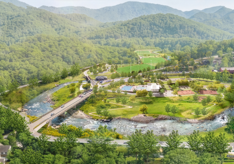
After six months of public input, the City of Asheville has merged thousands of community comments into a unified design for the Azalea Parks and Infrastructure Recovery Project which will rebuild and reimagine City-owned public spaces along the Swannanoa River catastrophically impacted by Tropical Storm Helene.
How to View the Design
The community can view the design concept through several channels:
- On-Site: Informational banners posted within the project area and nearby locations. Printed take-home versions are also available at Asheville Parks & Recreation community centers throughout the city.
- Digitally: View a video presentation or overview plans on the project web page, featuring an open comment window.
- Public Meeting Presentations: The project team presented the design concept at a joint meeting of the People and Environment and Infrastructure recovery boards, as well at the regular City Council meeting, on Tuesday, August 25. These presentations are available to replay on the City of Asheville’s YouTube channel.
Key Components of the Design
The unified concept is driven by community feedback, estimated disaster relief funding availability, resilient design, engineering analysis and flood modeling regarding the riverfront parks and infrastructure.
Parks and recreation amenities, including a competition pool, sports courts, and dog park will be restored and designed to better handle future flood events. A new loop trail around the John B. Lewis soccer complex expands opportunities for walking, running, and recreation.
The Gashes Creek Bridge will be rebuilt in a more resilient manner.
The new bridge will improve access and strengthen connectivity to the surrounding area. In the meantime, the City continues to work with the North Carolina Department of Transportation to install a temporary bridge to restore traffic patterns and relieve traffic congestion.
The damaged weir structure (formerly a hydroelectric dam) is being evaluated.
Originally built in 1924 as a combined hydroelectric dam and bridge, the hydroelectric component was decommissioned in 1952 and modified into a pass-through weir purely to support the bridge. The structure never served a flood-control purpose. The impacts of Helene rendered the bridge entirely dysfunctional. Exhaustive hydrological modeling and data collection confirm that removing this obsolete structure will not introduce additional flooding to any new properties, nor will it compromise community safety. Restoring the natural flow of the river also improves river safety for paddlers and water users, promotes natural mountain waterway ecology and aquatic life, and enhances accessibility and future recreation opportunities. The City is pursuing removal of this structure and is working with FEMA partners to consider the alternatives.
Next Steps
The City will host additional input opportunities this fall to focus on optimizing specific elements rather than altering the broader programming layout. In the meantime, the project team continues to develop and refine the design plans, which is expected to finish up in 2027 and will be followed by a phased construction approach on a timeline that is to be determined. Public access will be maximized throughout the duration of the project, allowing as many amenities as possible to be open for public use.